THE AUTHOR:

As you read this sentence, the global ocean is generating around 4,000–4,600 AIS messages per second. Leading maritime data providers process hundreds of millions of AIS messages daily, and for shipping companies, those signals translate directly into fuel use, timing, and safety.
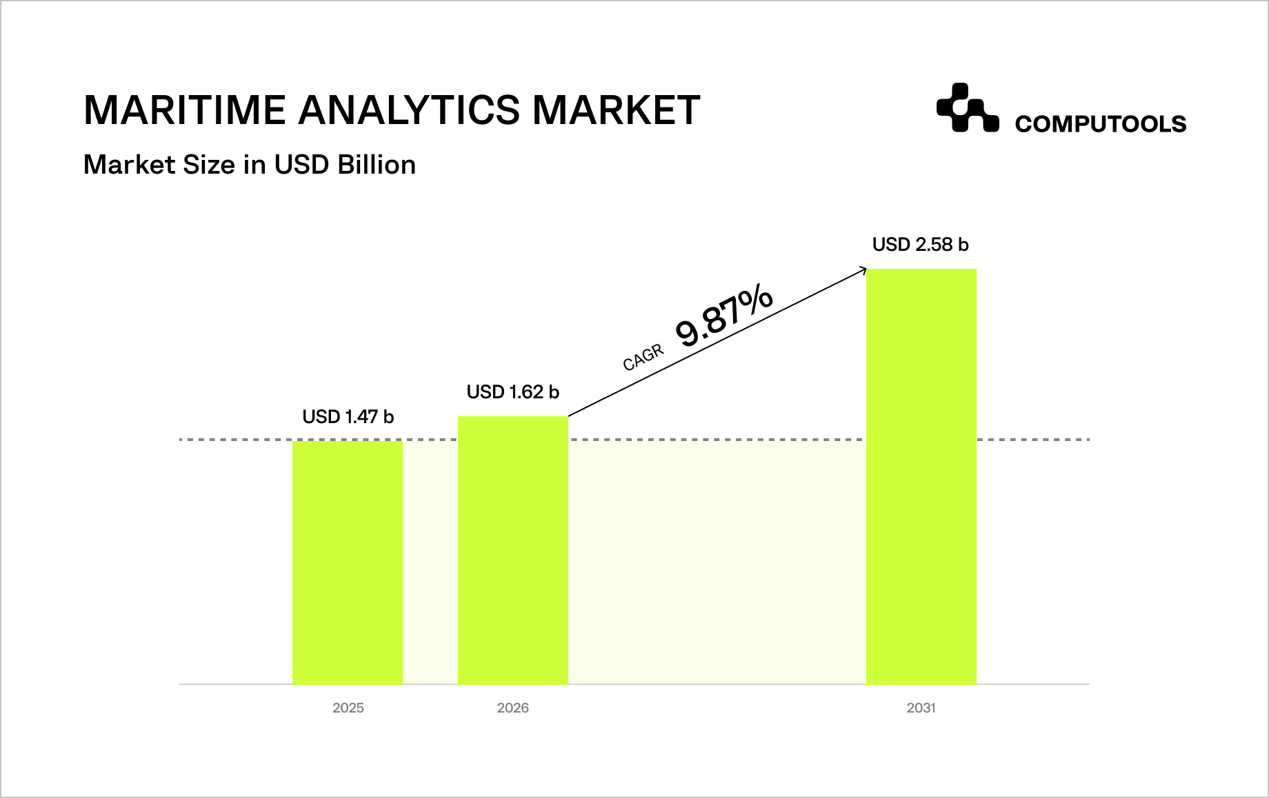
In 2026, the maritime analytics market crossed $1.6 billion, yet many operators still struggle with digital noise. The real challenge is not receiving AIS data but filtering noise, duplicates, missing values, and spoofed signals quickly enough to avoid misleading operational decisions.
Turning millions of raw coordinates into operational clarity requires more than data collection. It depends on the integration architecture that can unify AIS and GPS streams, validate them in real time, and convert them into decisions that improve routing, timing, and fuel efficiency.
Developing robust AIS GPS maritime integration software is no longer just an IT project. For many operators, it has become core operational infrastructure.
That matters because maritime transport still accounts for over 80% of global trade by volume, and even small delays or positioning errors can trigger financial losses, planning inefficiencies, and supply chain disruptions.
Many fleet operators still face a visibility gap: GPS data may arrive with latency, while AIS streams can contain inconsistencies, missing points, duplicates, or spoofed signals.
As a result, dispatchers often make time-sensitive decisions based on an incomplete operational picture, increasing the risk of congestion, route inefficiencies, and poor exception handling.
Advanced marine navigation data integration helps solve this by automatically cleansing and validating incoming data, enabling operators to move from reactive coordination to predictive management.
An integrated platform can flag anomalies early, support more reliable voyage planning, and strengthen compliance workflows related to IMO carbon-intensity and energy-efficiency requirements, which have been in force since 1 January 2023 and are under review through 2026.
How Computools built an AIS and GPS data integration platform for maritime cargo visibility
When a port logistics operator in Hamburg needed real-time cargo visibility across fragmented data sources, Computools delivered a unified platform that transformed operational coordination.
Leveraging our expertise in maritime software development services, we engineered Navis Horizon as a unified platform that integrates AIS, GPS, and carrier-event data into a single operational ecosystem.
Instead of forcing dispatchers to manually gather information from dozens of carrier and terminal portals, we implemented AIS and GPS data integration for maritime operations, consolidating carrier-event and port-event data into a single, real-time operational view.
This combined signals from MarineTraffic, VesselFinder, and partner GPS devices into a single, real-time source of truth, reducing data fragmentation and improving the reliability of cargo status updates.
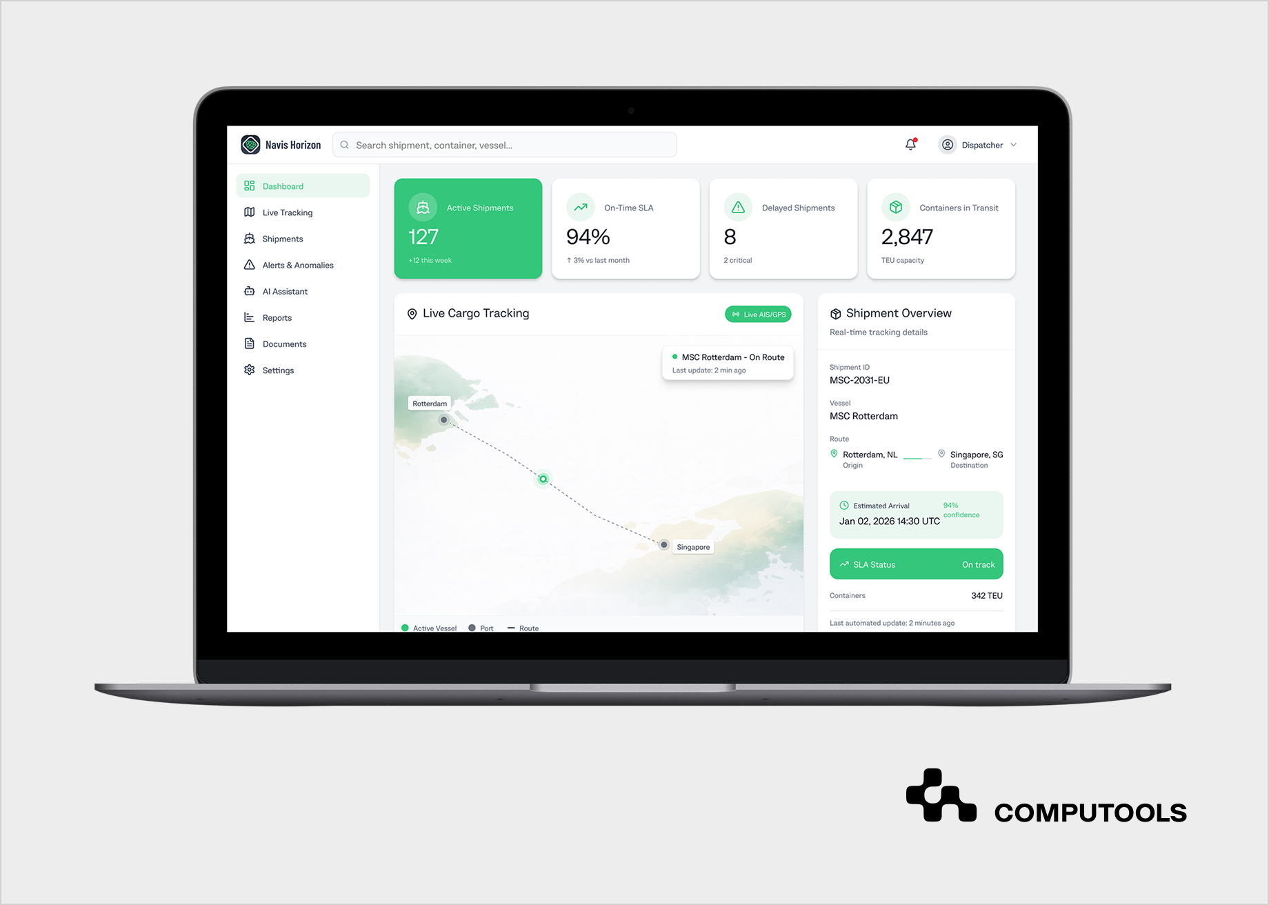
The foundation of this success lies in our data engineering services, which ensured the seamless processing of massive data volumes through a high-performance backend built in Golang and using WebSockets for instantaneous interface updates.
However, the true breakthrough was the implementation of our AI development services: we integrated an intelligent assistant powered by Python and LSTM models that goes beyond simple coordinate tracking to predict delays and anomalies before they escalate into disruptions.
This transformed the dispatcher’s role from reactive “firefighting” to proactive management, reducing manual workload by 40% and accelerating incident resolution by 18%.
Navis Horizon delivered measurable operational results, including a 40% reduction in dispatcher workload, a 23% increase in customer satisfaction, and a 18% reduction in the time to resolve shipment incidents.
The case demonstrates how unified data architecture and AI-assisted workflows can improve cargo visibility and operational responsiveness for port logistics operators.
Based on our extensive expertise and proven track record in delivering high-impact logistics solutions, we are now ready to provide a step-by-step guide to developing AIS and GPS data integration software for maritime operations, ensuring your software meets the rigorous demands of the 2026 global trade environment.
How to develop AIS and GPS data integration software for maritime operations: a strategic engineering guide
Step 1: Designing Hybrid Source Architecture and Data Aggregation Strategy
The first and most critical stage of development is crafting a data collection strategy that ensures global coverage without “blind spots.” True ship tracking software development begins with designing a data-fusion model that integrates satellite (S-AIS) and terrestrial (T-AIS) signals.
Developers must strike an optimal balance: terrestrial stations offer high-frequency updates (every 2–10 seconds) in coastal areas, while satellites provide visibility in the open ocean, albeit with higher latency.
At this stage, it is essential to establish a source prioritization system in which GPS data from a vessel’s private IoT terminals is given the highest level of trust, while public AIS data serves as a secondary verification layer.
Technically, this step requires creating a unified Data Access Layer that integrates APIs from multiple providers (such as Spire, Orbcomm, or MarineTraffic) via a single gateway. It is crucial to account for varying sampling rates: the system must be engineered to handle dynamic data transmission intervals, as a vessel in a high-traffic port generates significantly more events than one in transit.
The software architecture must also support a data lineage mechanism that traces the origin of every coordinate back to a specific source, which is critical for security auditing and calculating ETA accuracy.
In the Navis Horizon case, this stage focused on consolidating AIS, GPS, and carrier-event data into a single operational stream. This gave the client a more complete real-time view of cargo movement and reduced the fragmentation that previously slowed dispatcher workflows.
Step 2: Building a High-Concurrency Data Ingestion and Normalization Pipeline
Once the source strategy is defined, the next critical step is establishing an ingestion “factory” capable of maintaining high-throughput performance. Professional AIS data processing for maritime systems requires an architecture based on reactive programming and asynchronous processing.
The core element here is a distributed message broker like Apache Kafka, which acts as a resilient buffer (enabling backpressure management): if the influx of AIS messages from satellite providers spikes, Kafka holds the stream in topics, allowing processing services to ingest data at their maximum possible rate without losing a single packet.
Technical complexity at this stage lies in the Data Normalization Layer. Maritime data arrives in a chaotic array of formats: from binary AIVDM/AIVDO packets to complex proprietary JSON schemas from API providers. To handle this in real-time, it is highly recommended to use high-performance, low-latency languages such as Golang.
At this step, custom decoders are built to unpack binary data, validate checksums, and convert coordinates to the WGS84 coordinate system.
Each event is enriched with metadata: the server-side timestamp, source ID, and signal confidence index. This creates a clean internal data stream in which every vessel has a unified structure, regardless of the onboard hardware.
In the Navis Horizon project, we built a scalable backend architecture that supported stable processing of real-time AIS/GPS and carrier-event data. This enabled reliable status updates, reduced operational delays, and gave dispatchers a more accurate picture of cargo movement.
A more detailed overview of architectural requirements is available in the guide “How to Build a Real-Time Cargo Visibility Platform for Port and Maritime Logistics,” which discusses the technical infrastructure needed to ensure end-to-end transparency across complex sea routes.
Step 3: Implementing Intelligent Filtering and Signal Integrity
Even after successful normalization, the system must still handle signal noise. An effective GPS vessel monitoring system should identify and filter incoming data affected by transmission errors, atmospheric interference, duplicate packets, or deliberate spoofing of GPS coordinates.
To solve this, a multi-layered filtering pipeline should be implemented. The first layer performs temporal deduplication, detecting identical packets received simultaneously from different terrestrial and satellite stations and retaining only the signal with the highest RSSI.
The next stage validates vessel trajectories with Kalman filtering. By estimating the most likely next position from previous speed, direction, and motion dynamics, the system can detect implausible jumps and treat them as anomalies rather than valid location updates.
Static identifiers, such as MMSI numbers, are also verified to prevent confusion among vessels in dense traffic zones. To support this level of validation at scale, real-time stream processing is handled through Spark Streaming.
In the Navis Horizon project, we implemented custom validation and filtering logic to improve the consistency of AIS-based vessel tracks. This helped the client work with more stable movement data and supported more reliable operational planning.
Step 4: Synchronizing with Port Infrastructure and Terminal Systems
Once data is cleansed, the next evolution of a tracking system is its integration with shore-based infrastructure. Professional maritime IoT tracking goes beyond simple map visualization; it must synchronize a vessel’s movement with the port’s operational schedule.
This requires implementing Port Call Optimization practices that cross-reference AIS data with berth availability, pilotage services, and crane schedules. Technically, this can be realized by developing complex queuing models and BAP algorithms.
To achieve maximum efficiency, the system must support data exchange via EDI or modern REST APIs. This enables the software to automatically calculate the precise start of stevedoring operations based on the vessel’s real-time approach speed. It is also critical to process static vessel data, such as draft, length, and cargo type, to ensure the designated berth can accommodate the ship, given current hydrographic conditions and tide levels.
In our case, integration with port-event systems helped the operator align vessel movement data with port workflows more effectively. This improved shipment visibility, supported earlier issue detection, and made operational coordination more consistent.
To understand how these principles extend to land-based logistics, you can learn How to Integrate IoT Sensors With Railway Fleet Management Platforms, ensuring a seamless data flow between maritime and inland cargo monitoring systems.
Step 5: Automating Geofencing and Logistic Event Monitoring
To transform a simple map into a proactive tool, the system must recognize the geographical context of vessel movements. Advanced maritime fleet management software relies on dynamic geofencing to create virtual polygonal boundaries around ports, anchorage areas, and restricted zones.
Technically, this requires a high-performance spatial engine, such as PostGIS, capable of performing point-in-polygon queries for thousands of vessels in real time. When a vessel’s coordinates intersect a geofence, the system automatically triggers a specific event, such as an arrival or departure alert.
The core value lies in automating the logistics event log. Instead of relying on manual reports from captains or port agents, the system automatically timestamps ATA and ATD. This logic must account for dwell time to distinguish between a ship simply passing through a port area and one actually docking for operations. Using WebSockets, these status updates are pushed to the client’s dashboard in real time, providing cargo status visibility with minimal manual effort.
For platforms like Navis Horizon, automated event detection can reduce manual status tracking and improve the consistency of cargo updates across operational workflows. This helps dispatchers focus on exceptions rather than routine status handling.
Step 6: Implementing Environmental Monitoring and Fuel Consumption Analysis
In 2026, a tracking platform will no longer be complete without an emissions monitoring and carbon-performance module. Advanced AIS-based ship tracking systems can estimate voyage emissions in near real time and forecast carbon-intensity performance by combining movement data with vessel-specific operating characteristics.
This typically involves correlating AIS inputs, such as speed over ground, draft, and route profile, with fuel-consumption models to estimate fuel burn and CO₂ output, even when direct engine-room flow-meter data is unavailable. Since the IMO carbon-intensity framework and related reporting requirements have been in force since 1 January 2023, these capabilities help operators monitor environmental performance more proactively.
To support ESG reporting and compliance workflows, the platform should maintain a historical emissions record for every voyage. We implement this with a time-series database such as InfluxDB, which is optimized for time-stamped data and high write/query loads.
By analyzing the relationships among vessel speed, routing conditions, and estimated fuel consumption, the software can identify lower-emission operating scenarios, such as slow steaming or route adjustments.
The result is a stronger audit trail for internal and customer reporting, as well as carbon performance management.
At this stage, modern maritime platforms may also include capabilities for emissions monitoring and carbon performance reporting.
While this was not the central focus of the Navis Horizon case, these capabilities are becoming increasingly relevant for operators building next-generation maritime tracking platforms.
Step 7: Developing Predictive Analytics and AI Assistants
Modern software for maritime situational awareness should move beyond descriptive analytics toward predictive decision support.
At this stage, the platform introduces machine learning models for ETA forecasting, using historical transit data, seasonal weather patterns, vessel behavior, and current port congestion to generate more reliable arrival predictions. Unlike static linear calculations, these models help operators detect potential delays earlier and respond before disruptions affect port schedules or downstream operations.
Beyond ETA forecasting, AI assistants powered by LLMs and retrieval-augmented generation improve how users interact with complex maritime data. Instead of switching between multiple dashboards, a dispatcher can ask a natural-language question such as “Which vessels in the North Sea may miss their berthing window because of the incoming storm?”
The system retrieves relevant operational and contextual data, correlates it with weather and traffic conditions, and returns a concise, actionable summary. This reduces cognitive load for operators and helps teams respond more quickly during time-sensitive maritime events.
In the Navis Horizon case, Computools developed an AI assistant for both internal teams and external clients.
By consolidating AIS, GPS, and carrier data, the platform improved customer satisfaction by 23%, accelerated shipment incident resolution by 18%, and reduced dispatcher workload through more proactive, insight-driven operations.
Step 8: Ensuring Enterprise-Grade Security and Scalability
The final stage of logistics software development services is building a resilient infrastructure that ensures stable, uninterrupted access to operational data. Security plays a central role here, requiring alignment with GDPR and strong encryption for data both in transit and at rest.
A zero-trust approach at the frontend, combined with a modular backend architecture, helps protect sensitive shipment routes, operational records, and customer data from unauthorized access.
To support high-frequency data flows from multiple maritime tracking providers, the platform must also be built for scale. A containerized architecture makes it easier to add new routes, carriers, and integrations without major rework. As the volume of AIS and GPS signals grows, the system can maintain stable performance and provide a consistent operational view for all stakeholders across the logistics chain.
In the Navis Horizon project, Computools delivered a scalable platform that replaced fragmented data environments with a unified operational system. By integrating multiple carrier APIs and port-event systems, the solution improved cargo status visibility and created a more reliable foundation for operational coordination.
The result was an enterprise-grade platform that addressed current business needs while supporting future expansion across global trade routes.
Maritime tracking software development requires a structured engineering approach. It begins with a hybrid data fusion model to reduce coverage gaps and continues with a resilient ingestion pipeline capable of processing high-volume data streams.
The next stages include signal validation and filtering, synchronization with port infrastructure, and the deployment of spatial engines for automated geofencing. The architecture is then extended with emissions monitoring, predictive ETA modeling, and enterprise-grade security, resulting in a unified platform for more proactive and reliable logistics operations.
For a broader overview of the market, explore the 15 Best Vessel Tracking & Maritime Analytics Software Development Firms, which highlights the key standards for delivering scalable, high-concurrency solutions for global maritime operators.
Want to improve situational awareness across fleets, ports, and shipping routes? See how AIS–GPS software integration optimizes maritime operations.
The future of vessel tracking: trends for 2026–2027
The industry is shifting from basic digitalization to an era of intelligent, autonomous ecosystems.
To maintain a competitive edge, the next generation of marine vessel tracking technology must now account for several emerging shifts:
• LEO Satellite Connectivity: The integration of Low Earth Orbit (LEO) constellations enables high-bandwidth, low-latency communication even in the most remote oceanic corridors.
This allows for true real-time asset monitoring and seamless ship-to-shore data synchronization, previously impossible due to the bandwidth limitations of legacy satellite systems.
• Operational Digital Twins: Port terminals are increasingly adopting dynamic digital twins. Beyond simple 3D visualization, these maritime navigation software solutions integrate live data from cranes, vessels, and personnel to simulate “what-if” scenarios, allowing operators to predict congestion and optimize energy consumption before operations even begin.
• AI Agents and “Maritime Co-pilots”: Artificial Intelligence is evolving from a passive analytics tool into an active operational partner.
Autonomous AI agents will act as co-pilots for dispatchers, automatically optimizing routes, recalculating ETAs based on live weather, and suggesting schedule adjustments to mitigate port stay delays.
• Decarbonization and Automated ESG Reporting: With stricter environmental regulations, monitoring the Carbon Intensity Indicator (CII) is becoming a core requirement.
Modern tracking solutions now integrate fuel consumption data with hydrodynamic models, allowing vessels to automatically adopt “slow steaming” or optimized routing to meet green targets without compromising logistics schedules.
AIS GPS maritime integration software: why choose Computools as your technology partner?
Selecting a technology partner for AIS GPS vessel monitoring demands scale, mature compliance, and extensive maritime engineering expertise.
Computools leverages these strengths by providing secure, reliable, and effective maritime software development services to port operators and shipping companies.
WHY PARTNER WITH US:
1. Proven performance & ROI.
Our software powers global logistics, consistently delivering 45% faster voyage planning and port turnaround while driving 40% lower operational costs. We turn maritime challenges into measurable growth.
2. Scalable enterprise delivery capabilities.
With over 250 engineers and 10+ complex maritime projects completed, we possess the scale to build robust platforms that support global operations 24/7.
3. Specialized maritime expertise.
We provide professional software development services that help shipping companies and port operators optimize operations. From vessel tracking to port scheduling, we build software that reduces turnaround time and ensures visibility across sea routes.
4. IoT and connectivity engineering.
Our IoT development services enable seamless integration with marine sensors and satellite AIS providers, consolidating disparate data streams into a single source of truth for vessel monitoring.
5. Custom web and dashboard design.
Through custom web development, we create intuitive operational interfaces. Our platforms display shipment cards, global maps, and AI-driven sidebars, minimizing dispatchers’ cognitive load.
6. Certified quality and validation.
Trusted by global brands and rated 4.9 on Clutch, our solutions are based on ISO 9001 and ISO 27001 certified processes, guaranteeing enterprise-level security for your essential maritime operations.
This blend of technical skills, maritime expertise, and proven delivery makes Computools the top choice partner for operators seeking advanced AIS GPS maritime integration software. To discuss your project, contact our team at info@computools.com.
Conclusion
In 2026, success in global trade depends less on having the most data and more on processing it with integrity. Building strong digital systems means moving from sorting out noise to creating a digital version of the entire supply chain.
With scalable data pipelines, signal validation, and AI-powered predictive modeling, maritime operators can turn raw tracking data into a reliable operational asset. Using advanced AIS vessel tracking software helps companies achieve more than just visibility; it brings full operational coordination.
Computools
Software Solutions
Computools is an IT consulting and software development company that delivers innovative solutions to help businesses unlock tomorrow.


“Computools was selected through an RFP process. They were shortlisted and selected from between 5 other suppliers. Computools has worked thoroughly and timely to solve all security issues and launch as agreed. Their expertise is impressive.”